Shackelford Gorm E, Steward Peter R, German Richard N, Sait Steven M, Benton Tim G
Faculty of Biological Sciences, University of Leeds Leeds, LS2 9JT, UK.
Divers Distrib. 2015 Mar;21(3):357-367. doi: 10.1111/ddi.12291. Epub 2014 Dec 26.
Conservation conflict takes place where food production imposes a cost on wildlife conservation and vice versa. Where does conservation impose the maximum cost on production, by opposing the intensification and expansion of farmland? Where does conservation confer the maximum benefit on wildlife, by buffering and connecting protected areas with a habitable and permeable matrix of crop and non-crop habitat? Our aim was to map the costs and benefits of conservation versus production and thus to propose a conceptual framework for systematic conservation planning in agricultural landscapes.
World-wide.
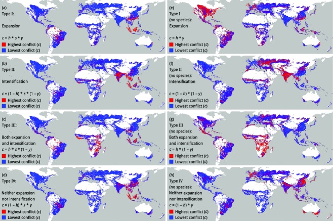
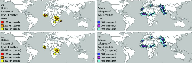
To quantify these costs and benefits, we used a geographic information system to sample the cropland of the world and map the proportion of non-crop habitat surrounding the cropland, the number of threatened vertebrates with potential to live in or move through the matrix and the yield gap of the cropland. We defined the potential for different types of conservation conflict in terms of interactions between habitat and yield (potential for expansion, intensification, both or neither). We used spatial scan statistics to find 'hotspots' of conservation conflict.
All of the 'hottest' hotspots of conservation conflict were in sub-Saharan Africa, which could have impacts on sustainable intensification in this region.
Systematic conservation planning could and should be used to identify hotspots of conservation conflict in agricultural landscapes, at multiple scales. The debate between 'land sharing' (extensive agriculture that is wildlife friendly) and 'land sparing' (intensive agriculture that is less wildlife friendly but also less extensive) could be resolved if sharing and sparing were used as different types of tool for resolving different types of conservation conflict (buffering and connecting protected areas by maintaining matrix quality, in different types of matrix). Therefore, both sharing and sparing should be prioritized in hotspots of conflict, in the context of countryside biogeography.
当粮食生产给野生动物保护带来成本,反之亦然时,就会发生保护冲突。通过反对农田集约化和扩张,保护措施在哪些地方给生产带来最大成本?通过用适宜居住且具有渗透性的作物和非作物栖息地矩阵来缓冲和连接保护区,保护措施在哪些地方给野生动物带来最大益处?我们的目的是绘制保护与生产的成本和效益图,从而为农业景观中的系统保护规划提出一个概念框架。
全球范围。
为了量化这些成本和效益,我们使用地理信息系统对世界农田进行采样,绘制农田周围非作物栖息地的比例、有可能在该矩阵中生活或穿行的受威胁脊椎动物数量以及农田的产量差距图。我们根据栖息地与产量之间的相互作用(扩张潜力、集约化潜力、两者皆有或两者皆无)来定义不同类型保护冲突的可能性。我们使用空间扫描统计来找出保护冲突的“热点”。
所有保护冲突“最热”的热点都在撒哈拉以南非洲,这可能会对该地区的可持续集约化产生影响。
系统保护规划能够且应该用于在多个尺度上识别农业景观中保护冲突的热点。如果将“土地共享”(对野生动物友好的粗放型农业)和“土地节约”(对野生动物不太友好但也不太粗放的集约型农业)用作解决不同类型保护冲突(通过在不同类型矩阵中维持矩阵质量来缓冲和连接保护区)的不同工具类型,那么“土地共享 ”和“土地节约”之间的争论就可以得到解决。因此,在乡村生物地理学背景下,冲突热点地区应同时优先考虑土地共享和土地节约。