Dewald Julius R, Fuller Douglas O, Müller Günter C, Beier John C
Department of Geography and Regional Studies, University of Miami, Coral Gables, FL, USA.
Kuvin Center for the Study of Tropical and Infectious Diseases, Hadassah Medical School, Hebrew University, Jerusalem, Israel.
Malar J. 2016 Sep 22;15(1):489. doi: 10.1186/s12936-016-1534-9.
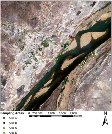
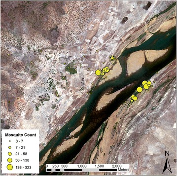
Knowledge of Anopheles resting habitats is needed to advance outdoor malaria vector control. This study presents a technique to map locations of resting habitats using high-resolution satellite imagery (world view 2) and probabilistic Dempster-Shafer (D-S) modelling, focused on a rural village in southern Mali, West Africa where field sampling was conducted to determine outdoor habitat preferences of Anopheles gambiae, the main vector in the study area.
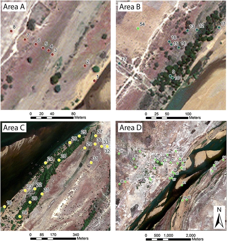
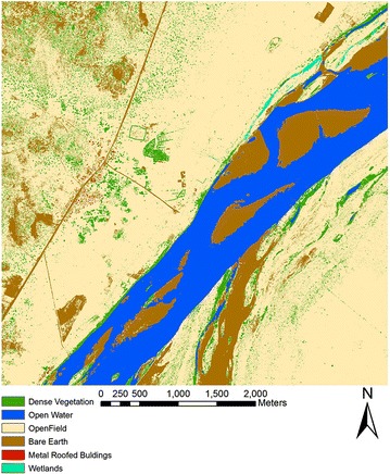
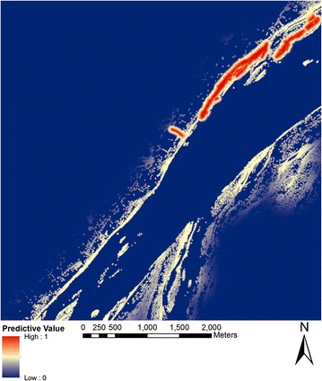
A combination of supervised and manual image classification was used to derive an accurate land-cover map from the satellite image that provided classes (i.e., photosynthetically active vegetation, water bodies, wetlands, and buildings) suitable for habitat assessment. Linear fuzzy functions were applied to the different image classes to scale resting habitat covariates into a common data range (0-1) with fuzzy breakpoints parameterized experimentally through comparison with mosquito outdoor resting data. Fuzzy layers were entered into a Dempster-Shafer (D-S) weight-of-evidence model that produced pixel-based probability of resting habitat locations.
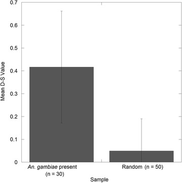
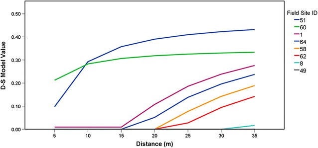
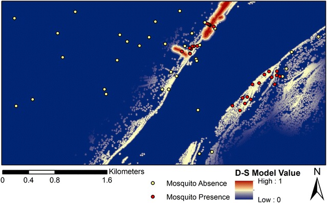
The D-S model provided a highly detailed suitability map of resting locations. The results indicated a significant difference (p < 0.001) between D-S values at locations positive for An. gambiae and a set of randomly sampled points. Further, a negative binomial regression indicated that although the D-S estimates did not predict abundance (p > 0.05) subsequent analysis suggested that the D-S modelling approach may provide a reasonable estimate locations of low-to-medium An. gambiae density. These results suggest that that D-S modelling performed well in identifying presence points and specifically resting habitats.
The use of a D-S modelling framework for predicting the outdoor resting habitat locations provided novel information on this little-known aspect of anopheline ecology. The technique used here may be applied more broadly at different geographic scales using Google Earth, Landsat or other remotely-sensed imagery to assess the malaria vector resting habitats where outdoor control measures can reduce the burden of the disease in Africa and elsewhere.
为推进室外疟疾媒介控制,需要了解按蚊的栖息生境。本研究提出了一种利用高分辨率卫星图像(world view 2)和概率性Dempster-Shafer(D-S)建模来绘制栖息生境位置的技术,研究重点是西非马里南部的一个乡村,在该地区进行了实地采样,以确定冈比亚按蚊(该研究区域的主要病媒)的室外生境偏好。
采用监督分类和人工图像分类相结合的方法,从卫星图像中得出准确的土地覆盖图,该图提供了适合生境评估的类别(即光合有效植被、水体、湿地和建筑物)。将线性模糊函数应用于不同的图像类别,以将栖息生境协变量缩放到共同的数据范围(0-1),通过与蚊子室外栖息数据进行比较,对模糊断点进行实验参数化。将模糊图层输入到Dempster-Shafer(D-S)证据权重模型中,该模型生成基于像素的栖息生境位置概率。
D-S模型提供了一份高度详细的栖息位置适宜性地图。结果表明,冈比亚按蚊阳性地点的D-S值与一组随机采样点之间存在显著差异(p < 0.001)。此外,负二项回归表明,虽然D-S估计值不能预测丰度(p > 0.05),但后续分析表明,D-S建模方法可能为中低密度冈比亚按蚊的位置提供合理估计。这些结果表明,D-S建模在识别存在点特别是栖息生境方面表现良好。
使用D-S建模框架预测室外栖息生境位置,为按蚊生态学这一鲜为人知的方面提供了新信息。这里使用的技术可以更广泛地应用于不同地理尺度,利用谷歌地球、陆地卫星或其他遥感图像来评估疟疾媒介的栖息生境,在这些地方,室外控制措施可以减轻非洲和其他地区的疾病负担。