Gómez-Barroso Diana, García-Carrasco Emely, Herrador Zaida, Ncogo Policarpo, Romay-Barja María, Ondo Mangue Martín Eka, Nseng Gloria, Riloha Matilde, Santana Maria Angeles, Valladares Basilio, Aparicio Pilar, Benito Agustín
CIBERESP, National Centre of Epidemiology, Carlos III Institute of Health (ISCIII), Madrid, Spain.
RICET, National Center of Tropical Medicine, Carlos III Institute of Health (ISCIII), Madrid, Spain.
Malar J. 2017 Apr 12;16(1):146. doi: 10.1186/s12936-017-1794-z.
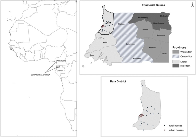
The transmission of malaria is intense in the majority of the countries of sub-Saharan Africa, particularly in those that are located along the Equatorial strip. The present study aimed to describe the current distribution of malaria prevalence among children and its environment-related factors as well as to detect malaria spatial clusters in the district of Bata, in Equatorial Guinea.
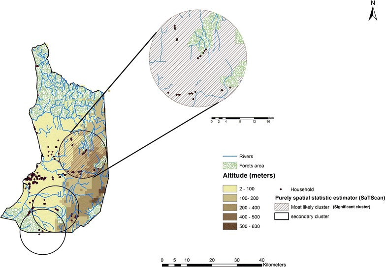
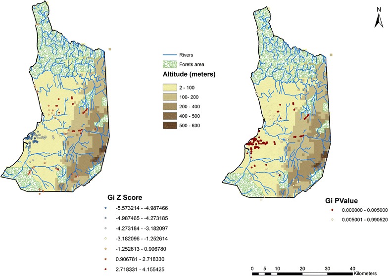
From June to August 2013 a representative cross-sectional survey using a multistage, stratified, cluster-selected sample was carried out of children in urban and rural areas of Bata District. All children were tested for malaria using rapid diagnostic tests (RDTs). Results were linked to each household by global position system data. Two cluster analysis methods were used: hot spot analysis using the Getis-Ord Gi statistic, and the SaTScan™ spatial statistic estimates, based on the assumption of a Poisson distribution to detect spatial clusters. In addition, univariate associations and Poisson regression model were used to explore the association between malaria prevalence at household level with different environmental factors.
A total of 1416 children aged 2 months to 15 years living in 417 households were included in this study. Malaria prevalence by RDTs was 47.53%, being highest in the age group 6-15 years (63.24%, p < 0.001). Those children living in rural areas were there malaria risk is greater (65.81%) (p < 0.001). Malaria prevalence was higher in those houses located <1 km from a river and <3 km to a forest (IRR: 1.31; 95% CI 1.13-1.51 and IRR: 1.44; 95% CI 1.25-1.66, respectively). Poisson regression analysis also showed a decrease in malaria prevalence with altitude (IRR: 0.73; 95% CI 0.62-0.86). A significant cluster inland of the district, in rural areas has been found.
This study reveals a high prevalence of RDT-based malaria among children in Bata district. Those households situated in inland rural areas, near to a river, a green area and/or at low altitude were a risk factor for malaria. Spatial tools can help policy makers to promote new recommendations for malaria control.
在撒哈拉以南非洲的大多数国家,尤其是位于赤道地区的国家,疟疾传播极为猖獗。本研究旨在描述儿童疟疾流行率的当前分布情况及其与环境相关的因素,并在赤道几内亚的巴塔区检测疟疾空间聚集区。
2013年6月至8月,在巴塔区城乡地区对儿童进行了一项具有代表性的横断面调查,采用多阶段、分层、整群抽样的样本。所有儿童均使用快速诊断检测(RDT)进行疟疾检测。结果通过全球定位系统数据与每个家庭相关联。使用了两种聚类分析方法:基于Getis-Ord Gi统计量的热点分析,以及基于泊松分布假设的SaTScan™空间统计估计,以检测空间聚集区。此外,使用单变量关联和泊松回归模型来探讨家庭层面疟疾流行率与不同环境因素之间的关联。
本研究共纳入了居住在417户家庭中的1416名年龄在2个月至15岁之间的儿童。通过RDT检测的疟疾流行率为47.53%,在6至15岁年龄组中最高(63.24%,p<0.001)。那些生活在农村地区的儿童感染疟疾的风险更高(65.81%)(p<0.001)。距离河流<1公里且距离森林<3公里的房屋中疟疾流行率更高(发病率比:1.31;95%置信区间1.13 - 1.51和发病率比:1.44;95%置信区间1.25 - 1.66)。泊松回归分析还显示,随着海拔升高疟疾流行率降低(发病率比:0.73;95%置信区间0.62 - 0.86)。在该地区内陆的农村地区发现了一个显著的聚集区。
本研究揭示了巴塔区儿童中基于RDT检测的疟疾高流行率。那些位于内陆农村地区、靠近河流、绿地和/或海拔较低的家庭是疟疾的危险因素。空间工具可以帮助政策制定者推广新的疟疾控制建议。