Mandal Siddhartha, Madhipatla Kishore K, Guttikunda Sarath, Kloog Itai, Prabhakaran Dorairaj, Schwartz Joel D
Center for Chronic Disease Control, New Delhi, India.
Public Health Foundation of India, New Delhi, India.
Atmos Environ (1994). 2020 Mar 1;224. doi: 10.1016/j.atmosenv.2020.117309. Epub 2020 Jan 27.
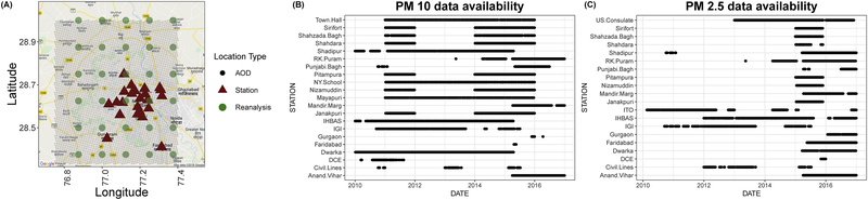
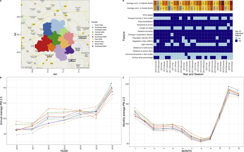
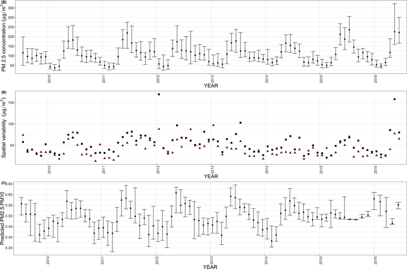
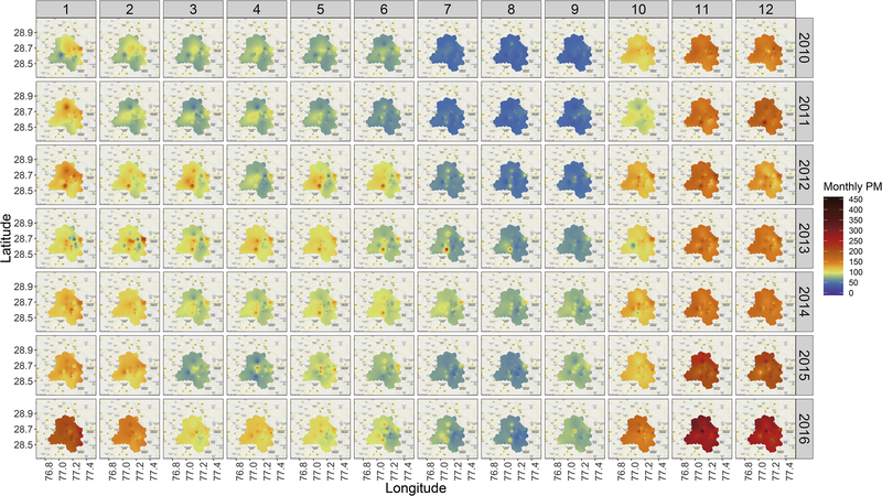
Elevated levels of ambient air pollution has been implicated as a major risk factor for morbidities and premature mortality in India, with particularly high concentrations of particulate matter in the Indo-Gangetic plain. High resolution spatiotemporal estimates of such exposures are critical to assess health effects at an individual level. This article retrospectively assesses daily average PM exposure at 1 km × 1 km grids in Delhi, India from 2010-2016, using multiple data sources and ensemble averaging approaches. We used a multi-stage modeling exercise involving satellite data, land use variables, reanalysis based meteorological variables and population density. A calibration regression was used to model PM: PM to counter the sparsity of ground monitoring data. The relationship between PM and its spatiotemporal predictors was modeled using six learners; generalized additive models, elastic net, support vector regressions, random forests, neural networks and extreme gradient boosting. Subsequently, these predictions were combined under a generalized additive model framework using a tensor product based spatial smoothing. Overall cross-validated prediction accuracy of the model was 80% over the study period with high spatial model accuracy and predicted annual average concentrations ranging from 87 to 138 μg/m. Annual average root mean squared errors for the ensemble averaged predictions were in the range 39.7-62.7 μg/m with prediction bias ranging between 4.6-11.2 μg/m. In addition, tree based learners such as random forests and extreme gradient boosting outperformed other algorithms. Our findings indicate important seasonal and geographical differences in particulate matter concentrations within Delhi over a significant period of time, with meteorological and land use features that discriminate most and least polluted regions. This exposure assessment can be used to estimate dose response relationships more accurately over a wide range of particulate matter concentrations.
在印度,室外空气污染水平升高被认为是发病和过早死亡的主要风险因素,尤其是在印度河-恒河平原,颗粒物浓度特别高。对这类暴露进行高分辨率时空估计对于评估个体层面的健康影响至关重要。本文回顾性评估了2010年至2016年印度德里1公里×1公里网格内的每日平均细颗粒物暴露情况,使用了多个数据源和集合平均方法。我们采用了一个多阶段建模过程,涉及卫星数据、土地利用变量、基于再分析的气象变量和人口密度。使用校准回归来模拟细颗粒物:为应对地面监测数据的稀疏性,对细颗粒物进行建模。使用六种学习器对细颗粒物与其时空预测因子之间的关系进行建模;广义相加模型、弹性网络、支持向量回归、随机森林、神经网络和极端梯度提升。随后,在广义相加模型框架下,使用基于张量积的空间平滑将这些预测结果进行合并。在整个研究期间,该模型的总体交叉验证预测准确率为80%,空间模型准确率较高,预测的年平均浓度范围为87至138微克/立方米。集合平均预测的年平均均方根误差在39.7至62.7微克/立方米之间,预测偏差在4.6至11.2微克/立方米之间。此外,基于树的学习器,如随机森林和极端梯度提升,表现优于其他算法。我们的研究结果表明,在相当长的一段时间内,德里市内细颗粒物浓度存在重要的季节和地理差异,气象和土地利用特征区分了污染最严重和最不严重的地区。这种暴露评估可用于在更广泛的细颗粒物浓度范围内更准确地估计剂量反应关系。