Gupta Devarupa, Biswas Dibyendu, Kabiraj Pintu
International Institute for Population Sciences, Govandi Station Road, Deonar, Mumbai, 400088 Maharashtra India.
Purulia, India.
GeoJournal. 2022;87(4):2719-2737. doi: 10.1007/s10708-021-10394-6. Epub 2021 Mar 3.
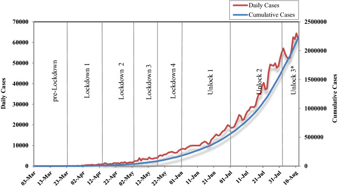
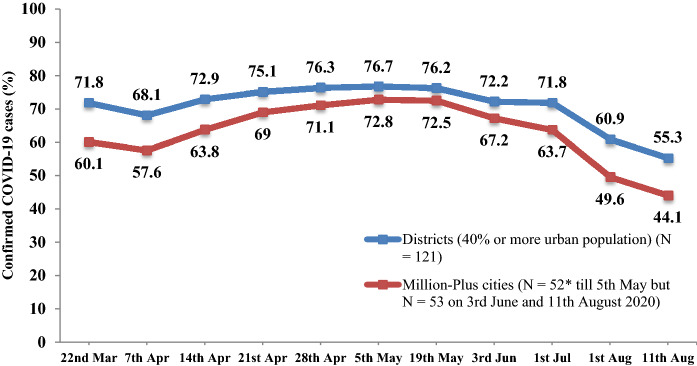
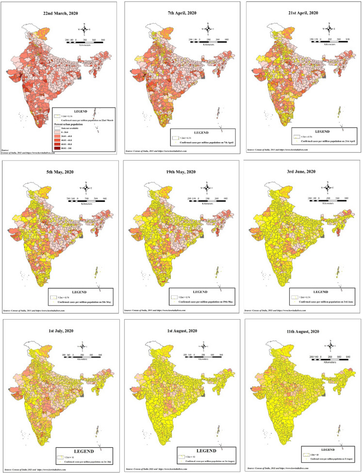
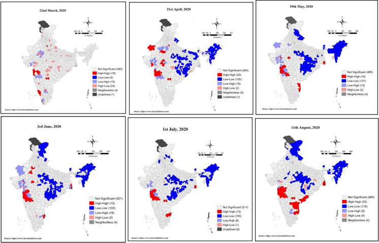
India was the second highest COVID-19 affected country in the world with 2.1 million cases by 11th August. This study focused on the spatial transmission of the pandemic among the 640 districts in India over time, and aimed to understand the urban-centric nature of the infection. The connectivity context was emphasized that possibly had inflicted the outbreak. Using the modes of transmission data for the available cases, the diffusion of this disease was explained. Metropolitans contributed three-fourths of total cases from the beginning. The transport networks attributed significantly in transmitting the virus from the urban containment zones. Later, there was a gradual shift of infections from urban to rural areas; however, the numbers kept increasing in the former. The massive reverse migration after lockdown spiked the infected cases further. Districts with airports reported more with influx of international passengers. A profound east-west division in April with higher infections in the southern and western districts existed. By mid-May eastern India saw a steep rise in active cases. Moran's I analysis showed a low autocorrelation initially which increased over time. Hotspot clustering was observed in western Maharashtra, eastern Tamil Nadu, Gujarat and around Kolkata by the second week of August. The diffusion was due to travel, exposure to infected individuals and among the frontline workers. Spatial regression models confirmed that urbanization was positively correlated with higher incidences of infections. Transit mediums, especially rail and aviation were positively associated. These models validated the crucial role of spatial proximity in diffusion of the pandemic.
印度是世界上受新冠疫情影响第二严重的国家,截至8月11日有210万例病例。本研究聚焦于疫情在印度640个地区随时间的空间传播,并旨在了解感染以城市为中心的性质。强调了可能导致疫情爆发的连通性背景。利用现有病例的传播方式数据,解释了这种疾病的扩散情况。从一开始,大城市就占了总病例数的四分之三。交通网络在将病毒从城市防控区传播出去方面起到了重要作用。后来,感染情况逐渐从城市向农村地区转移;然而,城市的感染人数仍在不断增加。封锁后大规模的反向迁移进一步增加了感染病例数。有机场的地区报告称,随着国际旅客的涌入,感染情况更为严重。4月份存在明显的东西部差异,南部和西部地区感染人数较多。到5月中旬,印度东部活跃病例数急剧上升。莫兰指数分析显示,最初自相关性较低,但随着时间推移而增加。到8月第二周,在马哈拉施特拉邦西部、泰米尔纳德邦东部、古吉拉特邦以及加尔各答周边地区观察到了热点聚集现象。传播是由于旅行、接触感染者以及一线工作人员之间的传播。空间回归模型证实,城市化与较高的感染发生率呈正相关。交通媒介,尤其是铁路和航空,呈正相关。这些模型验证了空间 proximity 在疫情扩散中的关键作用。 (注:原文中“proximity”直译为“接近”,结合语境这里“空间 proximity”可理解为空间上的邻近关系等意思,但具体需根据专业背景进一步确定准确含义)