• 文献检索
  • 文档翻译
  • 深度研究
  • 学术资讯
  • Suppr Zotero 插件Zotero 插件
  • 邀请有礼
  • 套餐&价格
  • 历史记录
应用&插件
Suppr Zotero 插件Zotero 插件浏览器插件Mac 客户端Windows 客户端微信小程序
定价
高级版会员购买积分包购买API积分包
服务
文献检索文档翻译深度研究API 文档MCP 服务
关于我们
关于 Suppr公司介绍联系我们用户协议隐私条款
关注我们

Suppr 超能文献

核心技术专利:CN118964589B侵权必究
粤ICP备2023148730 号-1Suppr @ 2026

文献检索

告别复杂PubMed语法,用中文像聊天一样搜索,搜遍4000万医学文献。AI智能推荐,让科研检索更轻松。

立即免费搜索

文件翻译

保留排版,准确专业,支持PDF/Word/PPT等文件格式,支持 12+语言互译。

免费翻译文档

深度研究

AI帮你快速写综述,25分钟生成高质量综述,智能提取关键信息,辅助科研写作。

立即免费体验

利用高分辨率卫星数据生成印度中部的土地覆盖和森林健康指标数据集。

Land cover and forest health indicator datasets for central India using very-high resolution satellite data.

机构信息

Department of Ecology, Evolution, and Environmental Biology, Columbia University, New York, NY, USA.

Department of Geography and Spatial Sciences, University of Delaware, Newark, DE, USA.

出版信息

Sci Data. 2023 Oct 25;10(1):738. doi: 10.1038/s41597-023-02634-w.

DOI:10.1038/s41597-023-02634-w
PMID:37880331
原文链接:https://pmc.ncbi.nlm.nih.gov/articles/PMC10600235/
Abstract

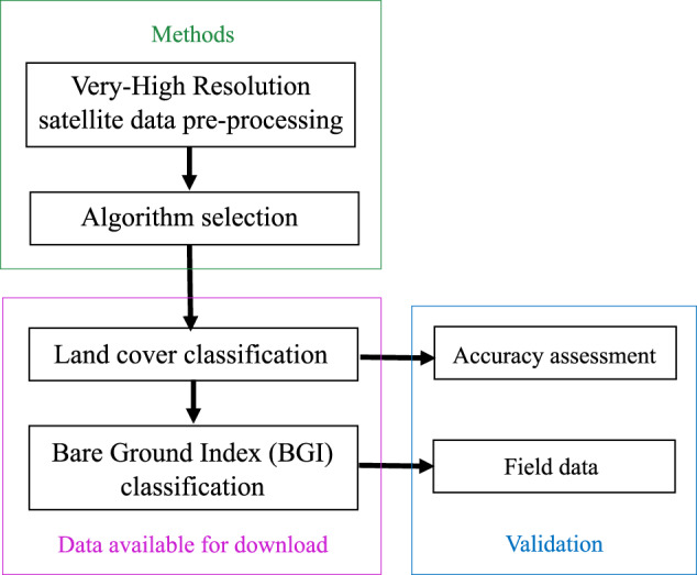
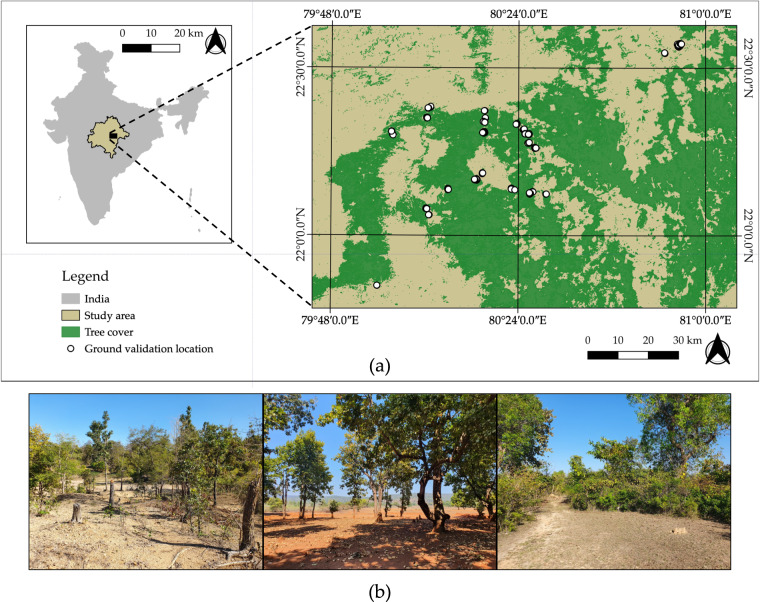
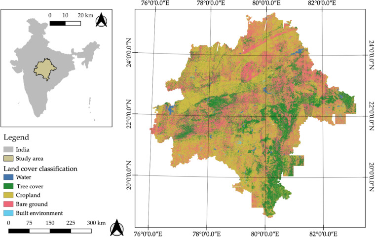
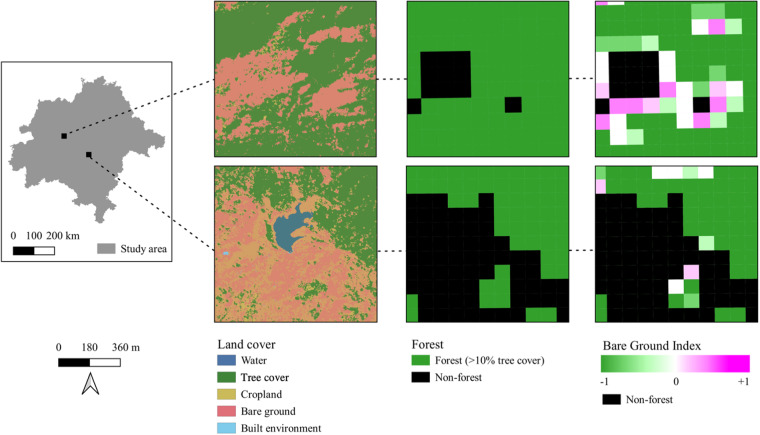
Satellite imagery has been used to provide global and regional estimates of forest cover. Despite increased availability and accessibility of satellite data, approaches for detecting forest degradation have been limited. We produce a very-high resolution 3-meter (m) land cover dataset and develop a normalized index, the Bare Ground Index (BGI), to detect and map exposed bare ground within forests at 90 m resolution in central India. Tree cover and bare ground was identified from Planet Labs Very High-Resolution satellite data using a Random Forest classifier, resulting in a thematic land cover map with 83.00% overall accuracy (95% confidence interval: 61.25%-90.29%). The BGI is a ratio of bare ground to tree cover and was derived by aggregating the land cover. Results from field data indicate that the BGI serves as a proxy for intensity of forest use although open areas occur naturally. The BGI is an indicator of forest health and a baseline to monitor future changes to a tropical dry forest landscape at an unprecedented spatial scale.

摘要

卫星图像已被用于提供全球和区域森林覆盖估计。尽管卫星数据的可用性和可访问性有所增加,但检测森林退化的方法仍然有限。我们生成了一个非常高分辨率的 3 米(m)土地覆盖数据集,并开发了一个归一化指数,即裸露地面指数(BGI),以检测和绘制印度中部森林内以 90 米分辨率裸露地面的位置。使用随机森林分类器从 Planet Labs 超高分辨率卫星数据中识别出树木覆盖和裸露地面,从而生成了一个主题土地覆盖图,总体准确率为 83.00%(置信区间:61.25%-90.29%)。BGI 是裸露地面与树木覆盖的比值,通过聚合土地覆盖数据得出。来自实地数据的结果表明,尽管自然存在开放区域,但 BGI 可作为森林利用强度的指标。BGI 是森林健康的指标,也是监测未来热带干旱林景观变化的基线,可以在前所未有的空间尺度上进行监测。

https://cdn.ncbi.nlm.nih.gov/pmc/blobs/ad65/10600235/5a581e737ffb/41597_2023_2634_Fig4_HTML.jpg
https://cdn.ncbi.nlm.nih.gov/pmc/blobs/ad65/10600235/e0c73cf19130/41597_2023_2634_Fig1_HTML.jpg
https://cdn.ncbi.nlm.nih.gov/pmc/blobs/ad65/10600235/ba47f182e9ef/41597_2023_2634_Fig2_HTML.jpg
https://cdn.ncbi.nlm.nih.gov/pmc/blobs/ad65/10600235/9f9107f6d360/41597_2023_2634_Fig3_HTML.jpg
https://cdn.ncbi.nlm.nih.gov/pmc/blobs/ad65/10600235/5a581e737ffb/41597_2023_2634_Fig4_HTML.jpg

相似文献

1
Land cover and forest health indicator datasets for central India using very-high resolution satellite data.利用高分辨率卫星数据生成印度中部的土地覆盖和森林健康指标数据集。
Sci Data. 2023 Oct 25;10(1):738. doi: 10.1038/s41597-023-02634-w.
2
Producing context specific land cover and land use maps of human-modified tropical forest landscapes for infectious disease applications.为传染病应用制作具有特定上下文的热带人工林景观的土地覆盖和土地利用图。
Sci Total Environ. 2024 Feb 20;912:168772. doi: 10.1016/j.scitotenv.2023.168772. Epub 2023 Nov 24.
3
Monitoring tropical forest succession at landscape scales despite uncertainty in Landsat time series.尽管 Landsat 时间序列存在不确定性,但仍能在景观尺度上监测热带森林演替。
Ecol Appl. 2021 Jan;31(1):e02208. doi: 10.1002/eap.2208. Epub 2020 Oct 5.
4
Continental estimates of forest cover and forest cover changes in the dry ecosystems of Africa between 1990 and 2000.1990年至2000年间非洲干旱生态系统森林覆盖及森林覆盖变化的大陆估计。
J Biogeogr. 2013 Jun;40(6):1036-1047. doi: 10.1111/jbi.12084.
5
Inconsistent estimates of forest cover change in China between 2000 and 2013 from multiple datasets: differences in parameters, spatial resolution, and definitions.2000 年至 2013 年中国森林覆盖变化的多数据集估计结果不一致:参数、空间分辨率和定义存在差异。
Sci Rep. 2017 Aug 18;7(1):8748. doi: 10.1038/s41598-017-07732-5.
6
[Landscape pattern changes at village scale using high resolution satellite images: A case study in low-slope hilly area of Dali City, Northwestern Yunnan Province].利用高分辨率卫星影像分析村落尺度景观格局变化——以滇西北大理市低山丘陵区为例
Ying Yong Sheng Tai Xue Bao. 2015 Dec;26(12):3803-10.
7
A global annual fractional tree cover dataset during 2000-2021 generated from realigned MODIS seasonal data.一个基于重新校准的MODIS季节数据生成的2000 - 2021年全球年度树木覆盖分数数据集。
Sci Data. 2024 Aug 1;11(1):832. doi: 10.1038/s41597-024-03671-9.
8
Monitoring forest dynamics with multi-scale and time series imagery.利用多尺度和时间序列影像监测森林动态。
Environ Monit Assess. 2016 May;188(5):273. doi: 10.1007/s10661-016-5271-x. Epub 2016 Apr 8.
9
A 50-m forest cover map in Southeast Asia from ALOS/PALSAR and its application on forest fragmentation assessment.利用ALOS/PALSAR绘制的东南亚50米森林覆盖图及其在森林破碎化评估中的应用。
PLoS One. 2014 Jan 22;9(1):e85801. doi: 10.1371/journal.pone.0085801. eCollection 2014.
10
The first generation of a regional-scale 1-m forest canopy cover dataset using machine learning and google earth engine cloud computing platform: A case study of Arkansas, USA.利用机器学习和谷歌地球引擎云计算平台生成的第一代区域尺度1米森林冠层覆盖数据集:以美国阿肯色州为例
Data Brief. 2023 Dec 30;52:109986. doi: 10.1016/j.dib.2023.109986. eCollection 2024 Feb.

引用本文的文献

1
Tropical dry woodland loss in India since 1880 and its relation to current megafauna distributions.自1880年以来印度热带干燥林地的丧失及其与当前大型动物分布的关系。
Ecol Appl. 2025 Jul;35(5):e70054. doi: 10.1002/eap.70054.

本文引用的文献

1
Firewood, forests, and fringe populations: Exploring the inequitable socioeconomic dimensions of Liquified Petroleum Gas (LPG) adoption in India.柴火、森林与边缘人群:探究印度液化石油气(LPG)使用中不公平的社会经济层面
Energy Res Soc Sci. 2021 May;75. doi: 10.1016/j.erss.2021.102012. Epub 2021 Mar 21.
2
Biocultural approaches to well-being and sustainability indicators across scales.生物文化方法在不同尺度上的幸福感和可持续性指标。
Nat Ecol Evol. 2017 Dec;1(12):1798-1806. doi: 10.1038/s41559-017-0349-6. Epub 2017 Oct 23.
3
Effect of elevated CO2, O3, and UV radiation on soils.
二氧化碳、臭氧和紫外线辐射增加对土壤的影响。
ScientificWorldJournal. 2014 Feb 6;2014:730149. doi: 10.1155/2014/730149. eCollection 2014.
4
High-resolution global maps of 21st-century forest cover change.高分辨率的 21 世纪全球森林覆盖变化地图集。
Science. 2013 Nov 15;342(6160):850-3. doi: 10.1126/science.1244693.
5
Global biodiversity scenarios for the year 2100.2100年全球生物多样性情景
Science. 2000 Mar 10;287(5459):1770-4. doi: 10.1126/science.287.5459.1770.