Canadian Facility for Ecoinformatics Research, Department of Biology, University of Ottawa, Ottawa, Ontario, Canada.
PLoS One. 2010 Feb 24;5(2):e9396. doi: 10.1371/journal.pone.0009396.
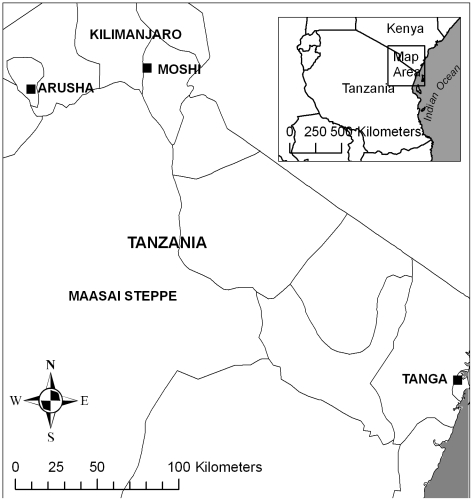
Malaria transmission rates in Africa can vary dramatically over the space of a few kilometres. This spatial heterogeneity reflects variation in vector mosquito habitat and presents an important obstacle to the efficient allocation of malaria control resources. Malaria control is further complicated by combinations of vector species that respond differently to control interventions. Recent modelling innovations make it possible to predict vector distributions and extrapolate malaria risk continentally, but these risk mapping efforts have not yet bridged the spatial gap to guide on-the-ground control efforts.
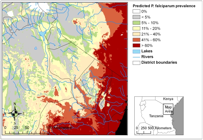
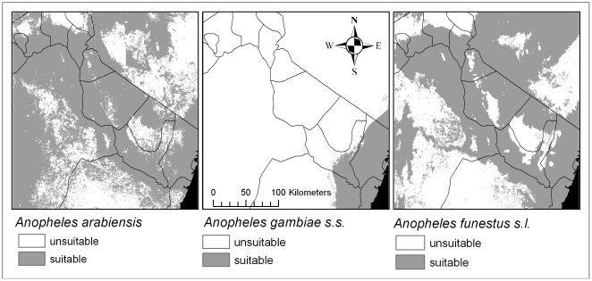
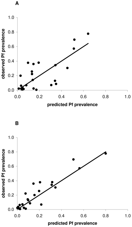
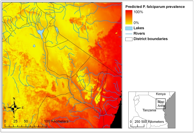
METHODOLOGY/PRINCIPAL FINDINGS: We used Maximum Entropy with purpose-built, high resolution land cover data and other environmental factors to model the spatial distributions of the three dominant malaria vector species in a 94,000 km(2) region of east Africa. Remotely sensed land cover was necessary in each vector's niche model. Seasonality of precipitation and maximum annual temperature also contributed to niche models for Anopheles arabiensis and An. funestus s.l. (AUC 0.989 and 0.991, respectively), but cold season precipitation and elevation were important for An. gambiae s.s. (AUC 0.997). Although these niche models appear highly accurate, the critical test is whether they improve predictions of malaria prevalence in human populations. Vector habitat within 1.5 km of community-based malaria prevalence measurements interacts with elevation to substantially improve predictions of Plasmodium falciparum prevalence in children. The inclusion of the mechanistic link between malaria prevalence and vector habitat greatly improves the precision and accuracy of prevalence predictions (r(2) = 0.83 including vector habitat, or r(2) = 0.50 without vector habitat). Predictions including vector habitat are unbiased (observations vs. model predictions of prevalence: slope = 1.02). Using this model, we generate a high resolution map of predicted malaria prevalence throughout the study region.
CONCLUSIONS/SIGNIFICANCE: The interaction between mosquito niche space and microclimate along elevational gradients indicates worrisome potential for climate and land use changes to exacerbate malaria resurgence in the east African highlands. Nevertheless, it is possible to direct interventions precisely to ameliorate potential impacts.
在几公里的范围内,非洲的疟疾传播率可能会有很大差异。这种空间异质性反映了媒介蚊子栖息地的变化,这是有效分配疟疾控制资源的一个重要障碍。媒介物种的组合使疟疾控制变得更加复杂,这些组合对控制干预的反应不同。最近的建模创新使得预测媒介分布并推断大陆疟疾风险成为可能,但这些风险绘图工作尚未弥合空间差距,无法为实地控制工作提供指导。
方法/主要发现:我们使用最大熵方法,结合专门构建的高分辨率土地覆盖数据和其他环境因素,对东非一个 94000 平方公里的区域内三种主要疟疾媒介物种的空间分布进行建模。每个媒介物的生态位模型都需要使用遥感土地覆盖数据。降水的季节性和最高年平均温度也为安蚊属(Anopheles)和芬氏按蚊复合体(An. funestus s.l.)的生态位模型做出了贡献(AUC 分别为 0.989 和 0.991),但冷季降水和海拔高度对冈比亚按蚊(An. gambiae s.s.)很重要(AUC 为 0.997)。尽管这些生态位模型看起来非常准确,但关键的测试是它们是否能提高对人群中疟疾流行率的预测。社区疟疾流行率测量值在 1.5 公里范围内的媒介栖息地与海拔高度相互作用,大大提高了儿童中恶性疟原虫流行率的预测。将疟疾流行率与媒介栖息地之间的机制联系纳入其中,大大提高了流行率预测的精度和准确性(包括媒介栖息地的 r(2) 为 0.83,不包括媒介栖息地的 r(2) 为 0.50)。包含媒介栖息地的预测是无偏的(观测值与模型预测的流行率:斜率=1.02)。利用该模型,我们生成了整个研究区域内预测疟疾流行率的高分辨率地图。
结论/意义:蚊子生态位空间与沿海拔梯度的小气候之间的相互作用表明,气候变化和土地利用变化有可能加剧东非高地的疟疾死灰复燃。尽管如此,仍然有可能将干预措施精确地引导到缓解潜在影响的方向。