• 文献检索
  • 文档翻译
  • 深度研究
  • 学术资讯
  • Suppr Zotero 插件Zotero 插件
  • 邀请有礼
  • 套餐&价格
  • 历史记录
应用&插件
Suppr Zotero 插件Zotero 插件浏览器插件Mac 客户端Windows 客户端微信小程序
定价
高级版会员购买积分包购买API积分包
服务
文献检索文档翻译深度研究API 文档MCP 服务
关于我们
关于 Suppr公司介绍联系我们用户协议隐私条款
关注我们

Suppr 超能文献

核心技术专利:CN118964589B侵权必究
粤ICP备2023148730 号-1Suppr @ 2026

文献检索

告别复杂PubMed语法,用中文像聊天一样搜索,搜遍4000万医学文献。AI智能推荐,让科研检索更轻松。

立即免费搜索

文件翻译

保留排版,准确专业,支持PDF/Word/PPT等文件格式,支持 12+语言互译。

免费翻译文档

深度研究

AI帮你快速写综述,25分钟生成高质量综述,智能提取关键信息,辅助科研写作。

立即免费体验

不同全球定位系统设备在空气污染流行病学研究中进行时间-位置跟踪的性能。

Performances of different global positioning system devices for time-location tracking in air pollution epidemiological studies.

作者信息

Wu Jun, Jiang Chengsheng, Liu Zhen, Houston Douglas, Jaimes Guillermo, McConnell Rob

机构信息

Program in Public Health, College of Health Sciences, University of California, Irvine, USA.

出版信息

Environ Health Insights. 2010 Nov 23;4:93-108. doi: 10.4137/EHI.S6246.

DOI:10.4137/EHI.S6246
PMID:21151593
原文链接:https://pmc.ncbi.nlm.nih.gov/articles/PMC3000001/
Abstract

BACKGROUND

People's time-location patterns are important in air pollution exposure assessment because pollution levels may vary considerably by location. A growing number of studies are using global positioning systems (GPS) to track people's time-location patterns. Many portable GPS units that archive location are commercially available at a cost that makes their use feasible for epidemiological studies.

METHODS

We evaluated the performance of five portable GPS data loggers and two GPS cell phones by examining positional accuracy in typical locations (indoor, outdoor, in-vehicle) and factors that influence satellite reception (building material, building type), acquisition time (cold and warm start), battery life, and adequacy of memory for data storage. We examined stationary locations (eg, indoor, outdoor) and mobile environments (eg, walking, traveling by vehicle or bus) and compared GPS locations to highly-resolved US Geological Survey (USGS) and Digital Orthophoto Quarter Quadrangle (DOQQ) maps.

RESULTS

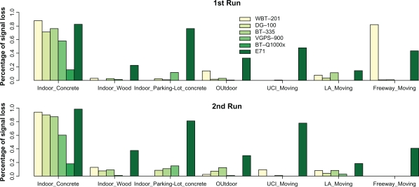
The battery life of our tested instruments ranged from <9 hours to 48 hours. The acquisition of location time after startup ranged from a few seconds to >20 minutes and varied significantly by building structure type and by cold or warm start. No GPS device was found to have consistently superior performance with regard to spatial accuracy and signal loss. At fixed outdoor locations, 65%-95% of GPS points fell within 20-m of the corresponding DOQQ locations for all the devices. At fixed indoor locations, 50%-80% of GPS points fell within 20-m of the corresponding DOQQ locations for all the devices except one. Most of the GPS devices performed well during commuting on a freeway, with >80% of points within 10-m of the DOQQ route, but the performance was significantly impacted by surrounding structures on surface streets in highly urbanized areas.

CONCLUSIONS

All the tested GPS devices had limitations, but we identified several devices which showed promising performance for tracking subjects' time location patterns in epidemiological studies.

摘要

背景

人们的时间-地点模式在空气污染暴露评估中很重要,因为不同地点的污染水平可能有很大差异。越来越多的研究使用全球定位系统(GPS)来追踪人们的时间-地点模式。许多可存档位置的便携式GPS设备在市场上有售,其成本使得它们可用于流行病学研究。

方法

我们通过检查在典型地点(室内、室外、车内)的定位精度以及影响卫星接收的因素(建筑材料、建筑类型)、获取时间(冷启动和热启动)、电池寿命和数据存储内存的充足性,评估了五款便携式GPS数据记录器和两款GPS手机的性能。我们考察了固定地点(如室内、室外)和移动环境(如步行、乘车或乘公交出行),并将GPS定位与高分辨率的美国地质调查局(USGS)地图和数字正射影像四分之一平方英里图(DOQQ)进行比较。

结果

我们测试的仪器的电池寿命从不到9小时到48小时不等。启动后获取位置的时间从几秒到超过20分钟不等,并且因建筑结构类型以及冷启动或热启动而有显著差异。在空间精度和信号丢失方面,没有发现哪款GPS设备始终具有卓越性能。在固定的室外地点,所有设备65% - 95%的GPS定位点落在相应DOQQ位置的20米范围内。在固定的室内地点,除一款设备外,所有设备50% - 80%的GPS定位点落在相应DOQQ位置的20米范围内。大多数GPS设备在高速公路通勤期间表现良好,超过80%的定位点落在DOQQ路线的10米范围内,但在高度城市化地区的地面街道上,其性能受到周围建筑的显著影响。

结论

所有测试的GPS设备都有局限性,但我们确定了几款在流行病学研究中追踪受试者时间-地点模式方面表现出良好前景的设备。

https://cdn.ncbi.nlm.nih.gov/pmc/blobs/ced3/3000001/66f958cf2d25/ehi-2010-093f5.jpg
https://cdn.ncbi.nlm.nih.gov/pmc/blobs/ced3/3000001/332b83da5fa9/ehi-2010-093f1.jpg
https://cdn.ncbi.nlm.nih.gov/pmc/blobs/ced3/3000001/05d73c3bd8dd/ehi-2010-093f2.jpg
https://cdn.ncbi.nlm.nih.gov/pmc/blobs/ced3/3000001/417bcca1a494/ehi-2010-093f4.jpg
https://cdn.ncbi.nlm.nih.gov/pmc/blobs/ced3/3000001/66f958cf2d25/ehi-2010-093f5.jpg

相似文献

1
Performances of different global positioning system devices for time-location tracking in air pollution epidemiological studies.不同全球定位系统设备在空气污染流行病学研究中进行时间-位置跟踪的性能。
Environ Health Insights. 2010 Nov 23;4:93-108. doi: 10.4137/EHI.S6246.
2
Automated time activity classification based on global positioning system (GPS) tracking data.基于全球定位系统 (GPS) 跟踪数据的自动时间活动分类。
Environ Health. 2011 Nov 14;10:101. doi: 10.1186/1476-069X-10-101.
3
Refining Time-Activity Classification of Human Subjects Using the Global Positioning System.利用全球定位系统优化人类受试者的时间-活动分类
PLoS One. 2016 Feb 26;11(2):e0148875. doi: 10.1371/journal.pone.0148875. eCollection 2016.
4
Comparing the Data Quality of Global Positioning System Devices and Mobile Phones for Assessing Relationships Between Place, Mobility, and Health: Field Study.比较全球定位系统设备和手机在评估地点、移动性与健康之间关系时的数据质量:实地研究。
JMIR Mhealth Uhealth. 2018 Aug 13;6(8):e168. doi: 10.2196/mhealth.9771.
5
Performance of GPS-devices for environmental exposure assessment.GPS 设备在环境暴露评估中的性能。
J Expo Sci Environ Epidemiol. 2013 Sep-Oct;23(5):498-505. doi: 10.1038/jes.2012.81. Epub 2012 Jul 25.
6
Usefulness of commercially available GPS data-loggers for tracking human movement and exposure to dengue virus.利用市售 GPS 数据记录器追踪人类活动和登革热病毒暴露的实用性。
Int J Health Geogr. 2009 Nov 30;8:68. doi: 10.1186/1476-072X-8-68.
7
Benefits of Mobile Phone Technology for Personal Environmental Monitoring.移动电话技术在个人环境监测中的益处。
JMIR Mhealth Uhealth. 2016 Nov 10;4(4):e126. doi: 10.2196/mhealth.5771.
8
Development of Time-location Weighted Spatial Measures Using Global Positioning System Data.利用全球定位系统数据开发时间-地点加权空间测量方法
Environ Health Toxicol. 2013 May 7;28:e2013005. doi: 10.5620/eht.2013.28.e2013005. Print 2013.
9
Integrating smart-phone based momentary location tracking with fixed site air quality monitoring for personal exposure assessment.将基于智能手机的瞬时位置跟踪与固定站点空气质量监测相结合,进行个人暴露评估。
Sci Total Environ. 2015 Feb 15;506-507:518-26. doi: 10.1016/j.scitotenv.2014.11.022. Epub 2014 Nov 28.
10
Applications of GPS-tracked personal and fixed-location PM(2.5) continuous exposure monitoring.全球定位系统跟踪的个人和固定地点细颗粒物(PM2.5)连续暴露监测的应用
J Air Waste Manag Assoc. 2016 Jan;66(1):53-65. doi: 10.1080/10962247.2015.1108942.

引用本文的文献

1
Systematic review of best practices for GPS data usage, processing, and linkage in health, exposure science and environmental context research.系统评价在健康、暴露科学和环境背景研究中使用、处理和链接 GPS 数据的最佳实践。
BMJ Open. 2024 Feb 1;14(2):e077036. doi: 10.1136/bmjopen-2023-077036.
2
Mapping Mobility: Utilizing Local-Knowledge-Derived Activity Space to Estimate Exposure to Ambient Air Pollution among Individuals Experiencing Unsheltered Homelessness.绘制流动轨迹:利用本地知识推导的活动空间来估算无家可归者个体的暴露于环境空气污染程度。
Int J Environ Res Public Health. 2022 May 11;19(10):5842. doi: 10.3390/ijerph19105842.
3

本文引用的文献

1
Development of a method for personal, spatiotemporal exposure assessment.一种用于个人时空暴露评估方法的开发。
J Environ Monit. 2009 Jul;11(7):1331-9. doi: 10.1039/b903841h. Epub 2009 Jun 3.
2
Conceptualizing the healthscape: contributions of time geography, location technologies and spatial ecology to place and health research.概念化健康景观:时间地理学、位置技术和空间生态学对场所与健康研究的贡献。
Soc Sci Med. 2010 Mar;70(5):668-76. doi: 10.1016/j.socscimed.2009.10.035. Epub 2009 Dec 4.
3
Usefulness of commercially available GPS data-loggers for tracking human movement and exposure to dengue virus.
Effects of Large-Scale Municipal Safe Routes to School Infrastructure on Student Active Travel and Physical Activity: Design, Methods, and Baseline Data of the Safe Travel Environment Evaluation in Texas Schools (STREETS) Natural Experiment.
大规模市级安全上学路径基础设施对学生主动出行和身体活动的影响:德克萨斯州学校安全出行环境评估(STREETS)自然实验的设计、方法和基线数据。
Int J Environ Res Public Health. 2022 Feb 5;19(3):1810. doi: 10.3390/ijerph19031810.
4
Use of wearable sensors to assess compliance of asthmatic children in response to lockdown measures for the COVID-19 epidemic.使用可穿戴传感器评估哮喘儿童对 COVID-19 疫情封锁措施的依从性。
Sci Rep. 2021 Mar 15;11(1):5895. doi: 10.1038/s41598-021-85358-4.
5
Differences in adolescent activity and dietary behaviors across home, school, and other locations warrant location-specific intervention approaches.青少年在家庭、学校和其他场所的活动和饮食行为存在差异,这需要针对特定地点采取干预措施。
Int J Behav Nutr Phys Act. 2020 Sep 29;17(1):123. doi: 10.1186/s12966-020-01027-1.
6
Beyond the bus stop: where transit users walk.公交站之外:公交乘客的步行范围
J Transp Health. 2019 Sep;14. doi: 10.1016/j.jth.2019.100604. Epub 2019 Aug 3.
7
Validating a GPS-based approach to detect health facility visits against maternal response to prompted recall survey.验证一种基于 GPS 的方法,通过提示回忆调查来检测产妇对医疗机构的就诊情况。
J Glob Health. 2020 Jun;10(1):010602. doi: 10.7189/jogh.10.010602.
8
Comparing GPS-Based Community Mobility Measures with Self-report Assessments in Older Adults with Parkinson's Disease.比较帕金森病老年患者基于全球定位系统的社区活动量测量与自我报告评估
J Gerontol A Biol Sci Med Sci. 2020 Nov 13;75(12):2361-2370. doi: 10.1093/gerona/glaa012.
9
Differences in Behavior, Time, Location, and Built Environment between Objectively Measured Utilitarian and Recreational Walking.客观测量的功利性步行与休闲性步行在行为、时间、地点和建成环境方面的差异。
Transp Res D Transp Environ. 2017 Dec;57:185-194. doi: 10.1016/j.trd.2017.09.026. Epub 2017 Oct 1.
10
Applications of Space Technologies to Global Health: Scoping Review.空间技术在全球健康领域的应用:范围综述
J Med Internet Res. 2018 Jun 27;20(6):e230. doi: 10.2196/jmir.9458.
利用市售 GPS 数据记录器追踪人类活动和登革热病毒暴露的实用性。
Int J Health Geogr. 2009 Nov 30;8:68. doi: 10.1186/1476-072X-8-68.
4
Global positioning system: a new opportunity in physical activity measurement.全球定位系统:身体活动测量的新机遇。
Int J Behav Nutr Phys Act. 2009 Nov 4;6:73. doi: 10.1186/1479-5868-6-73.
5
A criterion method for measuring route distance in physically active commuting.一种用于测量积极通勤中路线距离的标准方法。
Med Sci Sports Exerc. 2009 Feb;41(2):472-8. doi: 10.1249/MSS.0b013e3181877aaf.
6
Development of a wearable global positioning system for place and health research.用于场所与健康研究的可穿戴式全球定位系统的开发。
Int J Health Geogr. 2008 Nov 25;7:59. doi: 10.1186/1476-072X-7-59.
7
Using GPS-enabled cell phones to track the travel patterns of adolescents.使用具备全球定位系统功能的手机追踪青少年的出行模式。
Int J Health Geogr. 2008 May 21;7:22. doi: 10.1186/1476-072X-7-22.
8
Adolescent travel patterns: pilot data indicating distance from home varies by time of day and day of week.青少年出行模式:试点数据表明离家距离随一天中的时间和一周中的日期而变化。
J Adolesc Health. 2008 Apr;42(4):418-20. doi: 10.1016/j.jadohealth.2007.09.018. Epub 2007 Dec 21.
9
Utility of global positioning system to measure active transport in urban areas.全球定位系统在测量城市地区主动运输方面的效用。
Med Sci Sports Exerc. 2007 Oct;39(10):1851-7. doi: 10.1249/mss.0b013e31811ff31e.
10
GIS or GPS? A comparison of two methods for assessing route taken during active transport.地理信息系统还是全球定位系统?两种评估主动出行路线方法的比较
Am J Prev Med. 2007 Jul;33(1):51-3. doi: 10.1016/j.amepre.2007.02.042.