Geospatial Research, Analysis and Services Program (GRASP), Agency for Toxic Substances and Disease Registry, Centers for Disease Control and Prevention, 4770 Buford Hwy NE, Atlanta, GA, 30341, USA.
National Polio Emergency Operations Center, Abuja, Nigeria.
Int J Health Geogr. 2019 May 16;18(1):11. doi: 10.1186/s12942-019-0175-y.
Four wild polio-virus cases were reported in Borno State, Nigeria 2016, 1 year after Nigeria had been removed from the list of polio endemic countries by the World Health Organization. Resulting from Nigeria's decade long conflict with Boko Haram, health officials had been unable to access as much as 60% of the settlements in Borno, hindering vaccination and surveillance efforts. This lack of accessibility made it difficult for the government to assess the current population distribution within Borno. This study aimed to use high resolution, visible band satellite imagery to assess the habitation of inaccessible villages in Borno State.
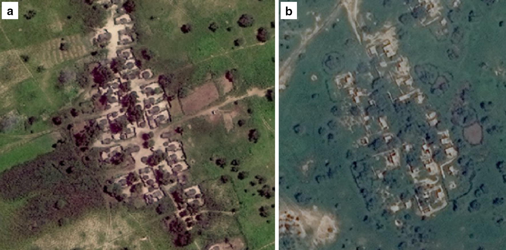
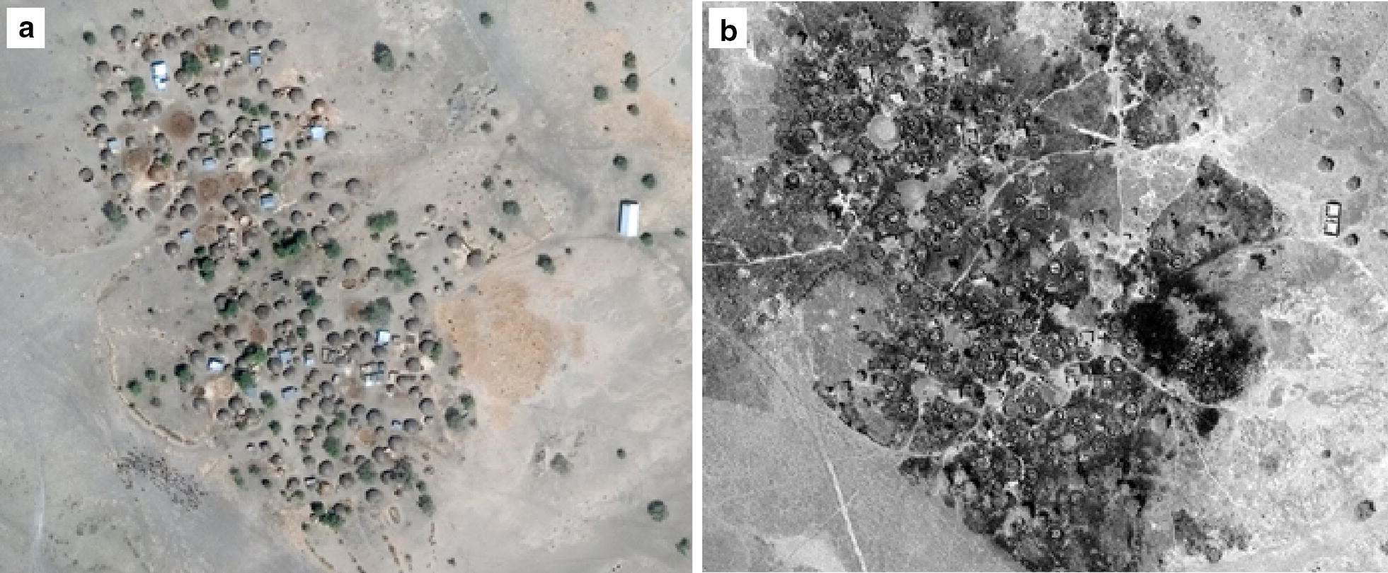
Using high resolution (31-50 cm) imagery from DigitalGlobe, analysts evaluated the habitation status of settlements in Borno State identified by Nigeria's Vaccination Tracking System. The analysts looked at imagery of each settlement and, using vegetation (overgrowth vs. cleared) as a proxy for human habitation, classified settlements into three categories: inhabited, partially abandoned, and abandoned. Analysts also classified the intact percentage of each settlement starting at 0% (totally destroyed since last assessment) and increasing in 25% intervals through 100% (completely intact but not expanded) up to 200+% (more than doubled in size) by looking for destroyed buildings. These assessments were then used to adjust previously established population estimates for each settlement. These new population distributions were compared to vaccination efforts to determine the number of children under 5 unreached by vaccination teams.
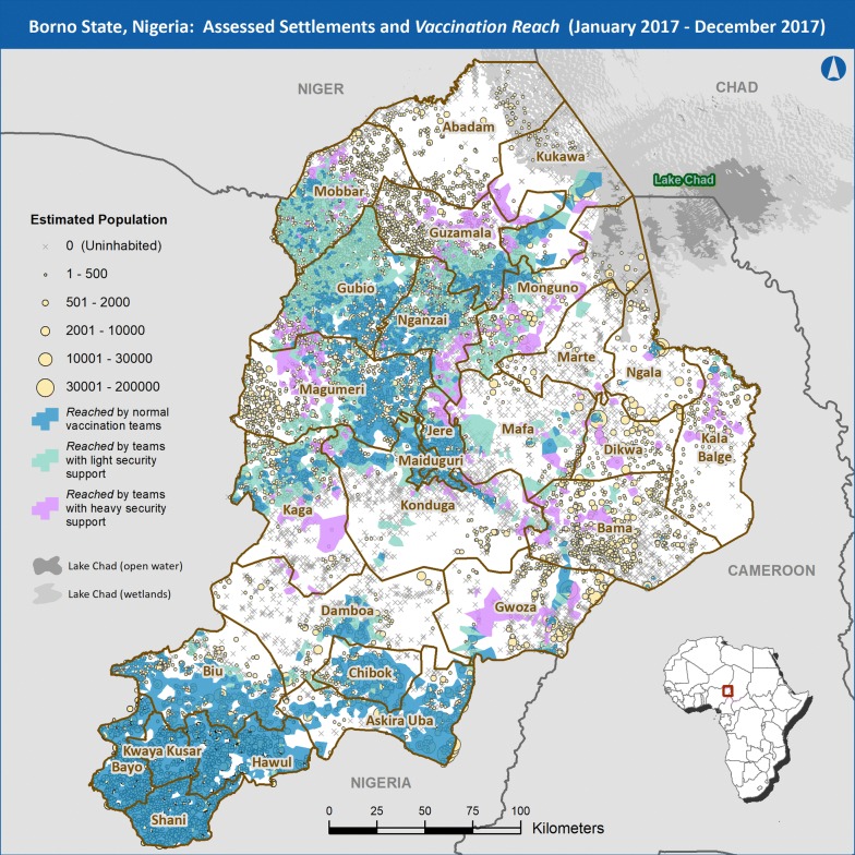
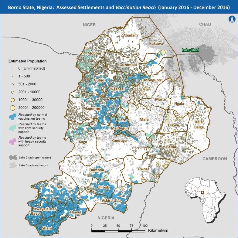
Of the 11,927 settlements assessed 3203 were assessed as abandoned (1892 of those completely destroyed), 662 as partially abandoned, and 8062 as fully inhabited as of December of 2017. Comparing the derived population estimates from the new assessments to previous assessment and the activities of vaccination teams shows that an estimated 180,155 of the 337,411 under five children who were unreached in 2016 were reached in 2017 (70.5% through vaccination efforts in previously inaccessible areas, 29.5% through displacement to accessible areas).
This study's methodology provides important planning and situation awareness information to health workers in Borno, Nigeria, and may serve as a model for future data gathering efforts in inaccessible regions.
2016 年,尼日利亚博尔诺州报告了 4 例野生脊灰病毒病例,此前一年,世界卫生组织已将尼日利亚从脊灰流行国家名单中删除。由于尼日利亚与博科圣地长达十年的冲突,卫生官员无法进入博尔诺 60%的定居点,这阻碍了疫苗接种和监测工作。这种无法进入的情况使得政府难以评估博尔诺州目前的人口分布情况。本研究旨在利用高分辨率可见光卫星图像评估博尔诺州难以进入的村庄的居住情况。
使用 DigitalGlobe 的高分辨率(31-50 厘米)图像,分析人员评估了尼日利亚疫苗接种跟踪系统确定的博尔诺州定居点的居住状况。分析人员查看每个定居点的图像,并使用植被(过度生长与清理)作为人类居住的替代指标,将定居点分为三类:有人居住、部分废弃和废弃。分析人员还通过寻找被摧毁的建筑物,从 0%(自上次评估以来完全被毁)开始,以 25%的间隔递增到 100%(完全完好但未扩建),最高可达 200%+%(面积增加一倍以上),对每个定居点的完整百分比进行分类。然后,使用这些评估结果来调整每个定居点的先前建立的人口估计。将这些新的人口分布与疫苗接种工作进行比较,以确定未被疫苗接种小组覆盖的 5 岁以下儿童人数。
在评估的 11927 个定居点中,截至 2017 年 12 月,有 3203 个被评估为废弃(其中 1892 个完全被毁),662 个为部分废弃,8062 个为完全有人居住。将新评估得出的人口估计数与以前的评估数以及疫苗接种小组的活动进行比较表明,在 2016 年未被覆盖的 337411 名 5 岁以下儿童中,估计有 180155 名(70.5%通过在以前无法进入的地区开展疫苗接种工作,29.5%通过转移到可进入地区)得到了覆盖。
本研究的方法为尼日利亚博尔诺州的卫生工作者提供了重要的规划和态势感知信息,并可能成为未来在难以进入地区进行数据收集工作的模型。