Mao Liang, Bian Ling
Department of Geography, University at Buffalo, State University of New York, Amherst, NY 14261, USA.
Comput Environ Urban Syst. 2010 May;34(3):204-215. doi: 10.1016/j.compenvurbsys.2010.03.004. Epub 2010 Apr 7.
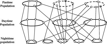
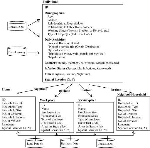
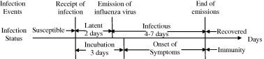
Cities and urban areas play an important role in fostering influenza transmission, often leading to epidemics and even pandemics. Although there is growing literature on influenza transmission at national and international scales, little attention has been paid to a city scale. This article aims to understand the spatial-temporal transmission of influenza and identify its health risks in the urbanized area of Buffalo, New York. An individual-based spatially explicit model is established to replicate an urban contact network, and simulate influenza epidemics. The resulting epidemic curves and infection intensity maps are used to analyze the transmission dynamics, possible contributing factors, and high-risk places and times. The results indicate that the city-wide transmission of influenza can be described by five stages: local growth, expansion, fast city-wide growth, slow city-wide growth, and fade-out. The places and times associated with higher risk are closely related to spatial heterogeneity in the population, and travel behaviors of individuals. Interestingly, these high-risk places and times are insensitive to where infection sources are introduced. This research suggests that high-risk places can be pre-identified as control targets using census and land use data. In addition, a better understanding on the city-wide travel of individuals is critical for designing proper timelines for influenza control. These suggestions will be valuable for local health agencies as they prepare to combat new waves of H1N1 influenza.
城市和城区在促进流感传播方面发挥着重要作用,常常引发流行病甚至大流行。尽管关于国家和国际层面流感传播的文献越来越多,但城市层面却很少受到关注。本文旨在了解纽约州布法罗城市化地区流感的时空传播情况,并确定其健康风险。建立了一个基于个体的空间显式模型来复制城市接触网络,并模拟流感疫情。所得的疫情曲线和感染强度图用于分析传播动态、可能的影响因素以及高风险场所和时间。结果表明,全市范围内的流感传播可分为五个阶段:局部增长、扩张、全市快速增长、全市缓慢增长和消退。与较高风险相关的场所和时间与人口的空间异质性以及个体的出行行为密切相关。有趣的是,这些高风险场所和时间对感染源引入的位置不敏感。这项研究表明,利用人口普查和土地利用数据可以预先确定高风险场所作为控制目标。此外,更好地了解个体在全市范围内的出行情况对于设计适当的流感控制时间表至关重要。这些建议对于当地卫生机构准备应对甲型H1N1流感新一波疫情将具有重要价值。