Yale University, School of Forestry & Environmental Studies, New Haven, CT, 06511, USA.
Yale University, Centre for Research Computing, New Haven, CT, 06511, USA.
Sci Data. 2020 May 28;7(1):162. doi: 10.1038/s41597-020-0479-6.
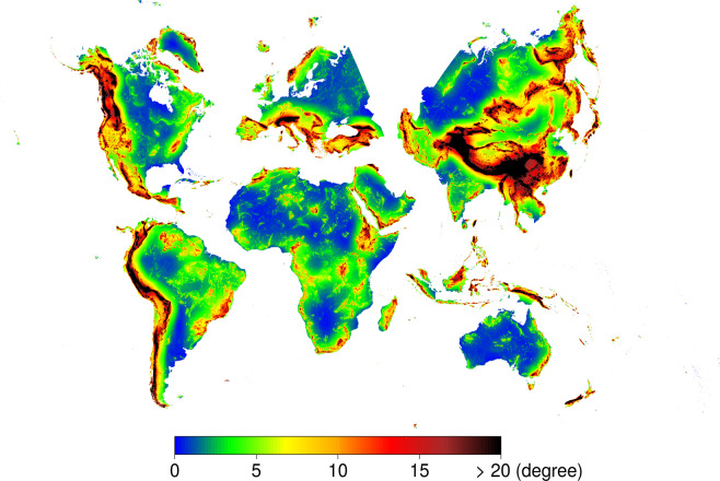
Topographical relief comprises the vertical and horizontal variations of the Earth's terrain and drives processes in geomorphology, biogeography, climatology, hydrology and ecology. Its characterisation and assessment, through geomorphometry and feature extraction, is fundamental to numerous environmental modelling and simulation analyses. We, therefore, developed the Geomorpho90m global dataset comprising of different geomorphometric features derived from the MERIT-Digital Elevation Model (DEM) - the best global, high-resolution DEM available. The fully-standardised 26 geomorphometric variables consist of layers that describe the (i) rate of change across the elevation gradient, using first and second derivatives, (ii) ruggedness, and (iii) geomorphological forms. The Geomorpho90m variables are available at 3 (90 m) and 7.5 arc-second (250 m) resolutions under the WGS84 geodetic datum, and 100 m spatial resolution under the Equi7 projection. They are useful for modelling applications in fields such as geomorphology, geology, hydrology, ecology and biogeography.
地形起伏包括地球地形的垂直和水平变化,驱动地貌学、生物地理学、气候学、水文学和生态学中的过程。通过地形测量学和特征提取对其进行特征描述和评估,是许多环境建模和模拟分析的基础。因此,我们开发了 Geomorpho90m 全球数据集,其中包含了不同的地形测量特征,这些特征是从 MERIT-Digital Elevation Model(DEM)中提取的,这是最好的全球高分辨率 DEM。这 26 个完全标准化的地形测量变量由以下三个部分组成:(i)使用一阶和二阶导数描述海拔梯度上的变化率;(ii)粗糙度;(iii)地形形态。Geomorpho90m 变量在 WGS84 大地基准下以 3(约 90 米)和 7.5 弧秒(约 250 米)的分辨率以及 Equi7 投影下的 100 米空间分辨率提供。它们可用于地貌学、地质学、水文学、生态学和生物地理学等领域的建模应用。