• 文献检索
  • 文档翻译
  • 深度研究
  • 学术资讯
  • Suppr Zotero 插件Zotero 插件
  • 邀请有礼
  • 套餐&价格
  • 历史记录
应用&插件
Suppr Zotero 插件Zotero 插件浏览器插件Mac 客户端Windows 客户端微信小程序
定价
高级版会员购买积分包购买API积分包
服务
文献检索文档翻译深度研究API 文档MCP 服务
关于我们
关于 Suppr公司介绍联系我们用户协议隐私条款
关注我们

Suppr 超能文献

核心技术专利:CN118964589B侵权必究
粤ICP备2023148730 号-1Suppr @ 2026

文献检索

告别复杂PubMed语法,用中文像聊天一样搜索,搜遍4000万医学文献。AI智能推荐,让科研检索更轻松。

立即免费搜索

文件翻译

保留排版,准确专业,支持PDF/Word/PPT等文件格式,支持 12+语言互译。

免费翻译文档

深度研究

AI帮你快速写综述,25分钟生成高质量综述,智能提取关键信息,辅助科研写作。

立即免费体验

缅甸保护区和非保护区控制植被火灾的因素。

Factors controlling vegetation fires in protected and non-protected areas of myanmar.

作者信息

Biswas Sumalika, Vadrevu Krishna Prasad, Lwin Zin Mar, Lasko Kristofer, Justice Christopher O

机构信息

Department of Geographical Sciences, University of Maryland, College Park, Maryland, United States of America.

Mandalay Technological University, Patheingyi, Mandalay, Myanmar.

出版信息

PLoS One. 2015 Apr 24;10(4):e0124346. doi: 10.1371/journal.pone.0124346. eCollection 2015.

DOI:10.1371/journal.pone.0124346
PMID:25909632
原文链接:https://pmc.ncbi.nlm.nih.gov/articles/PMC4409334/
Abstract

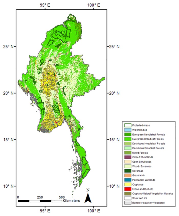
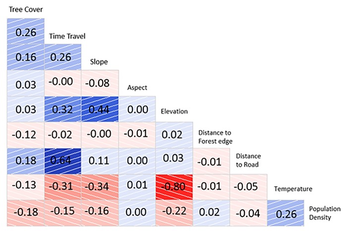
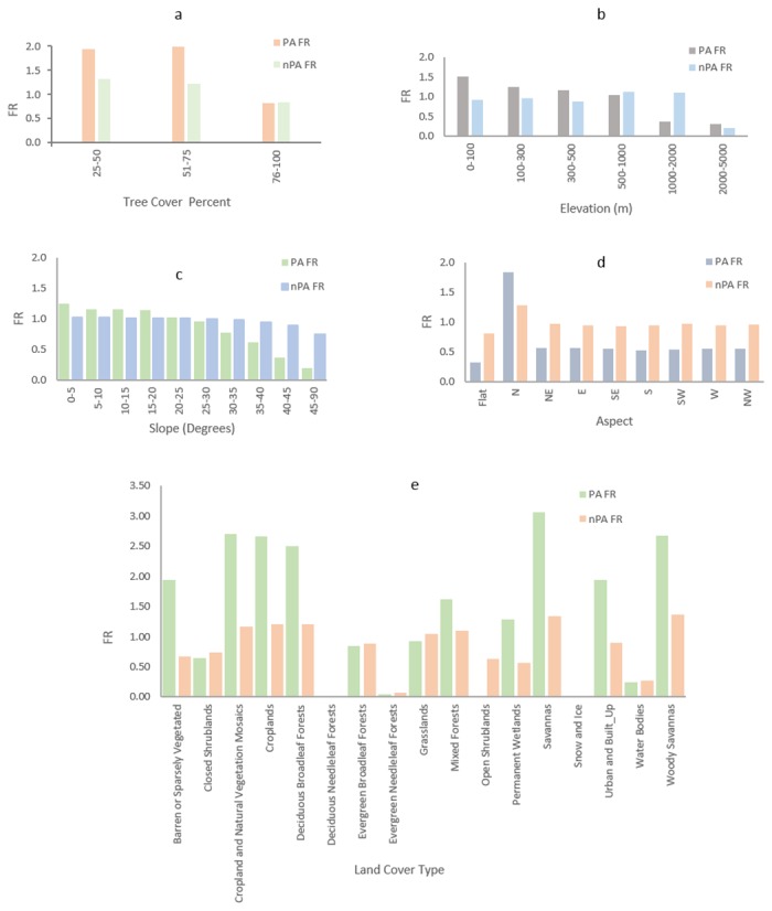
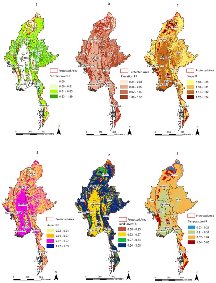
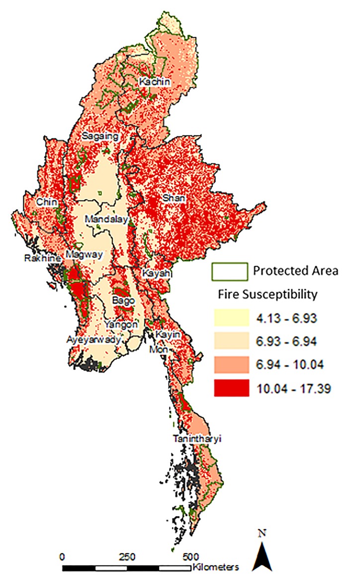
Fire is an important disturbance agent in Myanmar impacting several ecosystems. In this study, we quantify the factors impacting vegetation fires in protected and non-protected areas of Myanmar. Satellite datasets in conjunction with biophysical and anthropogenic factors were used in a spatial framework to map the causative factors of fires. Specifically, we used the frequency ratio method to assess the contribution of each causative factor to overall fire susceptibility at a 1km scale. Results suggested the mean fire density in non-protected areas was two times higher than the protected areas. Fire-land cover partition analysis suggested dominant fire occurrences in the savannas (protected areas) and woody savannas (non-protected areas). The five major fire causative factors in protected areas in descending order include population density, land cover, tree cover percent, travel time from nearest city and temperature. In contrast, the causative factors in non-protected areas were population density, tree cover percent, travel time from nearest city, temperature and elevation. The fire susceptibility analysis showed distinct spatial patterns with central Myanmar as a hot spot of vegetation fires. Results from propensity score matching suggested that forests within protected areas have 11% less fires than non-protected areas. Overall, our results identify important causative factors of fire useful to address broad scale fire risk concerns at a landscape scale in Myanmar.

摘要

火灾是缅甸一种重要的干扰因素,影响着多个生态系统。在本研究中,我们对影响缅甸保护区和非保护区植被火灾的因素进行了量化。结合生物物理和人为因素的卫星数据集被用于一个空间框架中,以绘制火灾的成因。具体而言,我们使用频率比方法来评估每个成因在1公里尺度上对整体火灾易发性的贡献。结果表明,非保护区的平均火灾密度是保护区的两倍。火灾-土地覆盖分区分析表明,火灾主要发生在稀树草原(保护区)和木本稀树草原(非保护区)。保护区的五大火灾成因按降序排列包括人口密度、土地覆盖、树木覆盖率、距最近城市的出行时间和温度。相比之下,非保护区的成因是人口密度、树木覆盖率、距最近城市的出行时间、温度和海拔。火灾易发性分析显示出明显的空间格局,缅甸中部是植被火灾的热点地区。倾向得分匹配结果表明,保护区内的森林火灾比非保护区少11%。总体而言,我们的结果确定了火灾的重要成因,有助于解决缅甸景观尺度上广泛的火灾风险问题。

https://cdn.ncbi.nlm.nih.gov/pmc/blobs/aebf/4409334/fc400037876b/pone.0124346.g005.jpg
https://cdn.ncbi.nlm.nih.gov/pmc/blobs/aebf/4409334/a258455ded4b/pone.0124346.g001.jpg
https://cdn.ncbi.nlm.nih.gov/pmc/blobs/aebf/4409334/f521f890d530/pone.0124346.g002.jpg
https://cdn.ncbi.nlm.nih.gov/pmc/blobs/aebf/4409334/d115f3f87605/pone.0124346.g003.jpg
https://cdn.ncbi.nlm.nih.gov/pmc/blobs/aebf/4409334/31da69937213/pone.0124346.g004.jpg
https://cdn.ncbi.nlm.nih.gov/pmc/blobs/aebf/4409334/fc400037876b/pone.0124346.g005.jpg

相似文献

1
Factors controlling vegetation fires in protected and non-protected areas of myanmar.缅甸保护区和非保护区控制植被火灾的因素。
PLoS One. 2015 Apr 24;10(4):e0124346. doi: 10.1371/journal.pone.0124346. eCollection 2015.
2
Spatial distribution of forest fires and controlling factors in Andhra Pradesh, India using SPOT satellite datasets.利用SPOT卫星数据集分析印度安得拉邦森林火灾的空间分布及控制因素
Environ Monit Assess. 2006 Dec;123(1-3):75-96. doi: 10.1007/s10661-005-9122-4. Epub 2006 Oct 20.
3
Landscape development, forest fires, and wilderness management.景观开发、森林火灾与荒野管理。
Science. 1974 Nov 8;186(4163):487-95. doi: 10.1126/science.186.4163.487.
4
Grazers, browsers, and fire influence the extent and spatial pattern of tree cover in the Serengeti.食草动物、食叶动物和火灾影响着塞伦盖蒂地区树木覆盖的范围和空间格局。
Ecol Appl. 2009 Jan;19(1):95-109. doi: 10.1890/07-1954.1.
5
Effects of fire on woody vegetation structure in African savanna.火对非洲热带稀树草原木本植被结构的影响。
Ecol Appl. 2010 Oct;20(7):1865-75. doi: 10.1890/09-0929.1.
6
Mapping regional patterns of large forest fires in Wildland-Urban Interface areas in Europe.绘制欧洲城乡交错带大型森林火灾的区域格局图。
J Environ Manage. 2016 May 1;172:112-26. doi: 10.1016/j.jenvman.2016.02.013. Epub 2016 Feb 27.
7
Spatial patterns in vegetation fires in the Indian region.印度地区植被火灾的空间格局。
Environ Monit Assess. 2008 Dec;147(1-3):1-13. doi: 10.1007/s10661-007-0092-6. Epub 2007 Dec 15.
8
Land cover change interacts with drought severity to change fire regimes in Western Amazonia.土地覆盖变化与干旱严重程度相互作用,改变了亚马孙西部地区的火灾状况。
Ecol Appl. 2014;24(6):1323-40. doi: 10.1890/13-2101.1.
9
Land cover, more than monthly fire weather, drives fire-size distribution in Southern Québec forests: Implications for fire risk management.土地覆盖而非月度火灾天气驱动了魁北克南部森林的火灾规模分布:对火灾风险管理的启示。
PLoS One. 2017 Jun 13;12(6):e0179294. doi: 10.1371/journal.pone.0179294. eCollection 2017.
10
Global ecosystems and fire: Multi-model assessment of fire-induced tree-cover and carbon storage reduction.全球生态系统与火灾:火灾导致的树木覆盖和碳储量减少的多模型评估。
Glob Chang Biol. 2020 Sep;26(9):5027-5041. doi: 10.1111/gcb.15160. Epub 2020 Jun 27.

引用本文的文献

1
Significant chlorine emissions from biomass burning affect the long-term atmospheric chemistry in Asia.生物质燃烧产生的大量氯排放影响亚洲地区的长期大气化学。
Natl Sci Rev. 2024 Aug 16;11(9):nwae285. doi: 10.1093/nsr/nwae285. eCollection 2024 Sep.
2
Forest fire vulnerability in Nepal's chure region: Investigating the influencing factors using generalized linear model.尼泊尔丘雷地区森林火灾脆弱性:使用广义线性模型调查影响因素
Heliyon. 2024 Mar 26;10(7):e28525. doi: 10.1016/j.heliyon.2024.e28525. eCollection 2024 Apr 15.
3
Spatial variations in vegetation fires and emissions in South and Southeast Asia during COVID-19 and pre-pandemic.

本文引用的文献

1
High-resolution global maps of 21st-century forest cover change.高分辨率的 21 世纪全球森林覆盖变化地图集。
Science. 2013 Nov 15;342(6160):850-3. doi: 10.1126/science.1244693.
2
Synthesis, characterization and cytocompatibility of spherical bioactive glass nanoparticles for potential hard tissue engineering applications.球形生物活性玻璃纳米粒子的合成、表征及细胞相容性研究及其在潜在的硬组织工程中的应用。
Biomed Mater. 2013 Apr;8(2):025011. doi: 10.1088/1748-6041/8/2/025011. Epub 2013 Mar 15.
3
Governance regime and location influence avoided deforestation success of protected areas in the Brazilian Amazon.
新冠疫情与大流行前时期南亚和东南亚植被火灾与排放的空间变化。
Sci Rep. 2022 Oct 29;12(1):18233. doi: 10.1038/s41598-022-22834-5.
4
Landscape characteristics influence ranging behavior of Asian elephants at the human-wildlands interface in Myanmar.景观特征影响缅甸人类与荒野交界处亚洲象的活动范围行为。
Mov Ecol. 2022 Feb 5;10(1):6. doi: 10.1186/s40462-022-00304-x.
5
Air Pollution From Forest and Vegetation Fires in Southeast Asia Disproportionately Impacts the Poor.东南亚森林和植被火灾造成的空气污染对贫困人口的影响尤为严重。
Geohealth. 2021 Sep 1;5(9):e2021GH000418. doi: 10.1029/2021GH000418. eCollection 2021 Sep.
6
Contemporary forest loss in Myanmar: Effect of democratic transition and subsequent timber bans on landscape structure and composition.缅甸当代森林损失:民主转型及其后木材禁令对景观结构和组成的影响。
Ambio. 2021 Apr;50(4):914-928. doi: 10.1007/s13280-020-01414-9. Epub 2021 Mar 7.
7
Short-run environmental effects of COVID-19: Evidence from forest fires.新冠疫情的短期环境影响:来自森林火灾的证据。
World Dev. 2021 Jan;137:105120. doi: 10.1016/j.worlddev.2020.105120. Epub 2020 Jul 31.
8
COVID-19's impact on the atmospheric environment in the Southeast Asia region.COVID-19 对东南亚地区大气环境的影响。
Sci Total Environ. 2020 Sep 20;736:139658. doi: 10.1016/j.scitotenv.2020.139658. Epub 2020 May 25.
9
Trends in Vegetation fires in South and Southeast Asian Countries.南亚和东南亚国家的植被火灾趋势。
Sci Rep. 2019 May 15;9(1):7422. doi: 10.1038/s41598-019-43940-x.
10
Satellites may underestimate rice residue and associated burning emissions in Vietnam.卫星可能低估了越南的水稻残茬及相关焚烧排放。
Environ Res Lett. 2017 Aug;12(8):085006. doi: 10.1088/1748-9326/aa751d. Epub 2017 Aug 10.
治理机制和地理位置影响巴西亚马孙保护区避免毁林的成功。
Proc Natl Acad Sci U S A. 2013 Mar 26;110(13):4956-61. doi: 10.1073/pnas.1214786110. Epub 2013 Mar 11.
4
Linking management effectiveness indicators to observed effects of protected areas on fire occurrence in the Amazon rainforest.将管理有效性指标与保护区对亚马逊热带雨林火灾发生的观测效应联系起来。
Conserv Biol. 2013 Feb;27(1):155-65. doi: 10.1111/j.1523-1739.2012.01930.x. Epub 2012 Sep 25.
5
Effectiveness of strict vs. multiple use protected areas in reducing tropical forest fires: a global analysis using matching methods.严格保护区与多次使用保护区在减少热带森林火灾方面的有效性:利用匹配方法进行的全球分析。
PLoS One. 2011;6(8):e22722. doi: 10.1371/journal.pone.0022722. Epub 2011 Aug 16.
6
Global and regional analysis of climate and human drivers of wildfire.全球和区域气候变化及人为因素对野火的驱动作用分析。
Sci Total Environ. 2011 Aug 15;409(18):3472-81. doi: 10.1016/j.scitotenv.2011.05.032.
7
Global land use change, economic globalization, and the looming land scarcity.全球土地利用变化、经济全球化与迫在眉睫的土地短缺
Proc Natl Acad Sci U S A. 2011 Mar 1;108(9):3465-72. doi: 10.1073/pnas.1100480108. Epub 2011 Feb 14.
8
Matching methods for causal inference: A review and a look forward.因果推断的匹配方法:综述与展望
Stat Sci. 2010 Feb 1;25(1):1-21. doi: 10.1214/09-STS313.
9
Protected areas reduced poverty in Costa Rica and Thailand.保护区减少了哥斯达黎加和泰国的贫困现象。
Proc Natl Acad Sci U S A. 2010 Jun 1;107(22):9996-10001. doi: 10.1073/pnas.0914177107. Epub 2010 May 24.
10
Extent of the global network of terrestrial protected areas.陆地保护区全球网络的范围。
Conserv Biol. 2010 Apr;24(2):362-3. doi: 10.1111/j.1523-1739.2010.01465.x.