Department of Environmental Sciences, Jahangirnagar University, Dhaka, 1342, Bangladesh.
Institute of Energy, University of Dhaka, Dhaka, 1000, Bangladesh.
Environ Monit Assess. 2021 Jan 4;193(1):29. doi: 10.1007/s10661-020-08810-4.
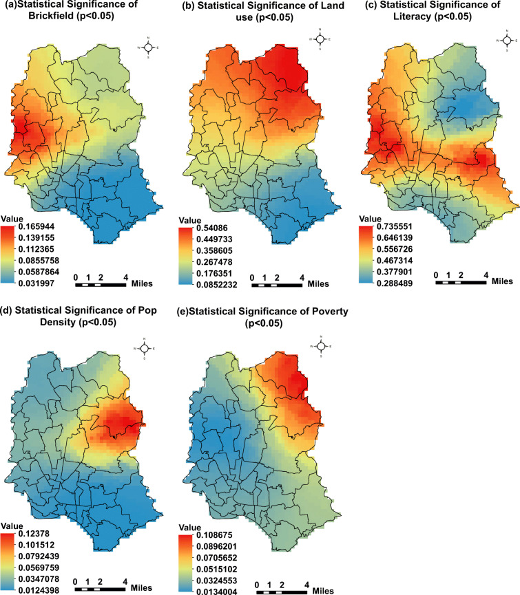
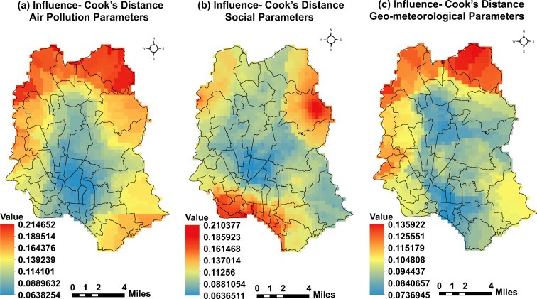
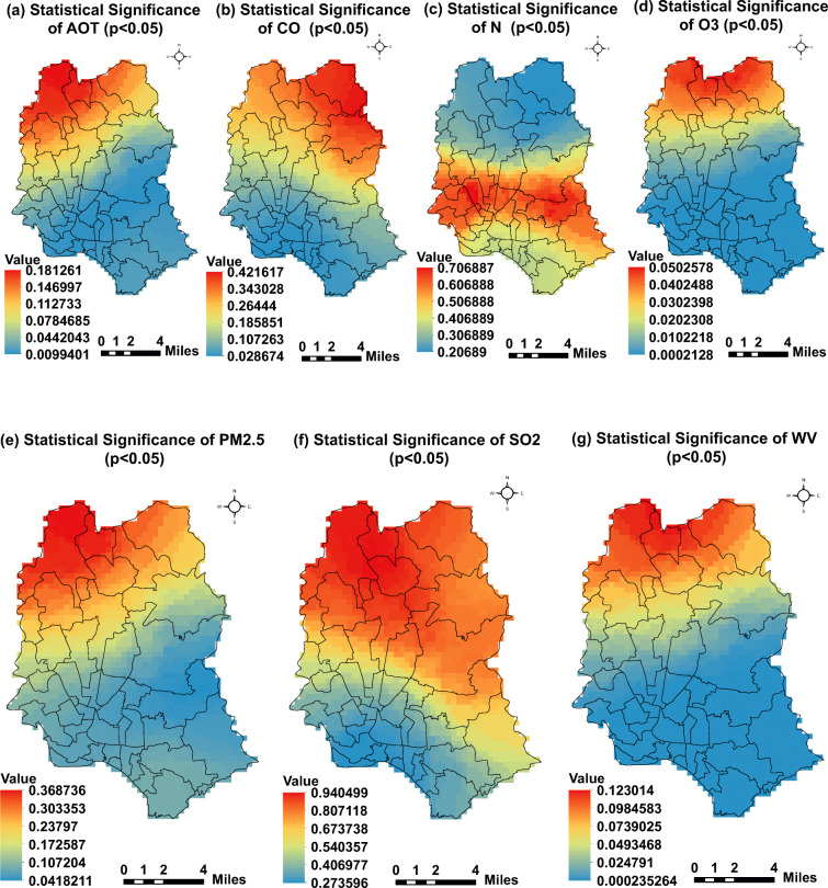
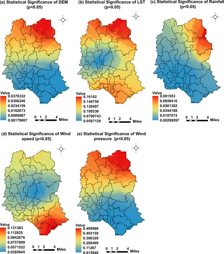
Like all infectious diseases, the infection rate of COVID-19 is dependent on many variables. In order to effectively prepare a localized plan for infectious disease management, it is important to find the relationship between COVID-19 infection rate and other key variables. This study aims to understand the spatial relationships between COVID-19 infection rate and key variables of air pollution, geo-meteorological, and social parameters in Dhaka, Bangladesh. The relationship was analyzed using Geographically Weighted Regression (GWR) model and Geographic Information System (GIS) by means of COVID-19 infection rate as a dependent variable and 17 independent variables. This study revealed that air pollution parameters like PM (p < 0.02), AOT (p < 0.01), CO (p < 0.05), water vapor (p < 0.01), and O (p < 0.01) were highly correlated with COVID-19 infection rate while geo-meteorological parameters like DEM (p < 0.01), wind pressure (p < 0.01), LST (p < 0.04), rainfall (p < 0.01), and wind speed (p < 0.03) were also similarly associated. Social parameters like population density (p < 0.01), brickfield density (p < 0.02), and poverty level (p < 0.01) showed high coefficients as the key independent variables to COVID-19 infection rate. Significant robust relationships between these factors were found in the middle and southern parts of the city where the reported COVID-19 infection case was also higher. Relevant agencies can utilize these findings to formulate new and smart strategies for reducing infectious diseases like COVID-19 in Dhaka and in similar urban cities around the world. Future studies will have more variables including ecological, meteorological, and economical to model and understand the spread of COVID-19.
与所有传染病一样,COVID-19 的感染率取决于许多变量。为了有效制定传染病管理的局部计划,找到 COVID-19 感染率与其他关键变量之间的关系非常重要。本研究旨在了解 COVID-19 感染率与空气污染、地理气象和社会参数等关键变量在孟加拉国达卡的空间关系。使用地理加权回归(GWR)模型和地理信息系统(GIS),通过 COVID-19 感染率作为因变量和 17 个独立变量来分析这种关系。研究表明,空气污染参数如 PM(p<0.02)、AOT(p<0.01)、CO(p<0.05)、水汽(p<0.01)和 O(p<0.01)与 COVID-19 感染率高度相关,而地理气象参数如 DEM(p<0.01)、风压(p<0.01)、LST(p<0.04)、降雨(p<0.01)和风速(p<0.03)也有类似的关联。人口密度(p<0.01)、砖厂密度(p<0.02)和贫困水平(p<0.01)等社会参数作为 COVID-19 感染率的关键独立变量,其系数也较高。在城市中部和南部发现了这些因素之间存在显著的稳健关系,这些地区报告的 COVID-19 感染病例也较高。相关机构可以利用这些发现,为达卡和世界上类似的城市制定新的、智能的策略,以减少 COVID-19 等传染病的传播。未来的研究将包括更多的变量,如生态、气象和经济,以建模和理解 COVID-19 的传播。